Parks Parks with Trails
Location:
9644 Reservoir Rd, Roanoke, VA 24019, United States
Phone:
Parks and Recreation Main Office: 540-853-2236 or Carvins Cove Boat Landing Office: 540-362-1757

Carvins Cove Natural Reserve

ROANOKE’S HIDDEN OUTDOOR GEM

Located just seven miles from the north side of Roanoke, Carvins Cove Natural Reserve contains more than 12,000 acres of both hardwood and mixed pine forests, a 630-acre reservoir and 60 miles of trails for hiking, mountain biking and horseback riding. More than 11,200 acres of Carvins Cove Natural Reserve is protected by the largest conservation easement in Virginia’s history. Roanoke’s Carvins Cove is a vital piece of Virginia’s green infrastructure and also a source of fresh water. Rainfall drains from the natural reserve into the beautiful Carvins Cove reservoir. The reservoir’s water is treated and 10-million gallons of water is filtered each day for customers of the Western Virginia Water Authority, who manages the Cove’s boat dock and reservoir access.

Park Hours

Park Hours:

The Boat Landing at the Reservoir and Hollins Parking Lot:

Open seven days a week except Thanksgiving Day and Christmas Day
April 1 through September 30: 6:30 AM to 9:30 PM
October 1 through March 31: 8:30 AM to 6:30 PM

The boat landing parking lot closes at dark and is locked overnight. Please contact the Western Virginia Water Authority with any questions.

Bennett Springs and Timberview Parking Lots: 

April 1 through October 31: 6:00 AM to 10:00 PM  
November 1 through March 31: 8:00 AM to 7:00 PM 

Directions & Parking

GETTING THERE:

Carvins Cove Natural Reserve has three parking lot entrances: the Boat Landing at the Reservoir, Bennett Springs, and Timberview. Each parking lot is conveniently located within a 10-15 minute drive of downtown Roanoke. Once you arrive, you will have to pay for parking and use.

  • Individual/Vehicle Passes:
    $7 per car daily/$50 per vehicle yearly (includes land use and use of personal kayaks, SUP, non-motorized or non-trailered boats)
  • Equestrian Trailer Pass:
    $10 daily/ $75 yearly
  • Personal Boat with Trailer Pass:
    $12 daily/$100 yearly

Passes are required for anyone over the age of 16. Visitors who are age 15 or under must be accompanied by a parent or guardian.

Individual/Vehicle passes and Equestrian Trailer passes can be purchased online at Reservations, Passes, & Permits, in-person at the office at the Boat Landing, or with cash or check at the payment drop boxes located at the Bennett Springs and Timberview parking lots.  Debit and credit cards are only accepted online.  Boating passes must be purchased in-person at the office at the Boat Landing.


1. BOAT LANDING PARKING LOT

Head to the Boat Landing Parking Lot if you want to access the water and trails on the Hollins side of Carvins Cove. The boat dock parking lot closes at dark and is locked overnight, so please do not park your car here if you plan to stay in the park after dark. For more information about certain restrictions concerning reservoir use and hours, please contact the Western Virginia Water Authority at 540-362-1757. Amenities include: Picnic Tables, Restrooms, Boat Rentals, Security Personnel and Parking. Address: 9644 Reservoir Road, Roanoke, VA 24019

GOOGLE MAP


2. BENNETT SPRINGS PARKING LOT

If you’re looking for Carvins Cove’s extensive mountain biking, hiking or equestrian trails, then the Bennett Springs Parking Lot is the right access point for you! Travel along Route 311 to find the Bennett Springs Parking Lot. You’ll have access to nearly 60 miles of trails. Amenities include: Parking, Trail Conditions Signs, Bike Fix Station, Restrooms. Address: 4300 Carvins Cove Road, Salem, VA 24153

GOOGLE MAP


3. TIMBERVIEW ROAD PARKING LOT

This parking lot is tucked at the junction of Horsepens Trail and Trough Trail at Carvins Cove. Access Timberview Road Parking Lot via Dutch Oven Road. Address: 3399 Timberview Road, Roanoke VA 24019.

GOOGLE MAP
Rules

Carvins Cove RULES:

Rules and user fees help provide recreational opportunities for visitors while still maintaining the safest, highest quality drinking water possible.

  • Visitors age 16 or under must be accompanied by a parent or guardian at all times.
  • Safety education is recommended before engaging in paddling activities at Carvins Cove.
  • Your dog is welcome in the park, but they must remained leashed at all times. Please help take care of the watershed by picking up all waste from your dogs and horses.
  • There are two picnic shelters available at the Carvins Cove Boat Landing. The smaller of the two is open to all guests during park hours.  The large picnic shelter can be reserved for a daily rental fee. For details and reservations, please see our Reservations, Passes & Permits Page.
  • Swimming and camping are not permitted at Carvins Cove.
  • Alcohol is prohibited at Carvins Cove.
  • For the safety of our visitors, personal drone use is prohibited within the Carvins Cove Natural Reserve. Commercial drone operators must get written permission from the Western Virginia Water Authority before being permitted to fly within the watershed.
History of Carvins Cove
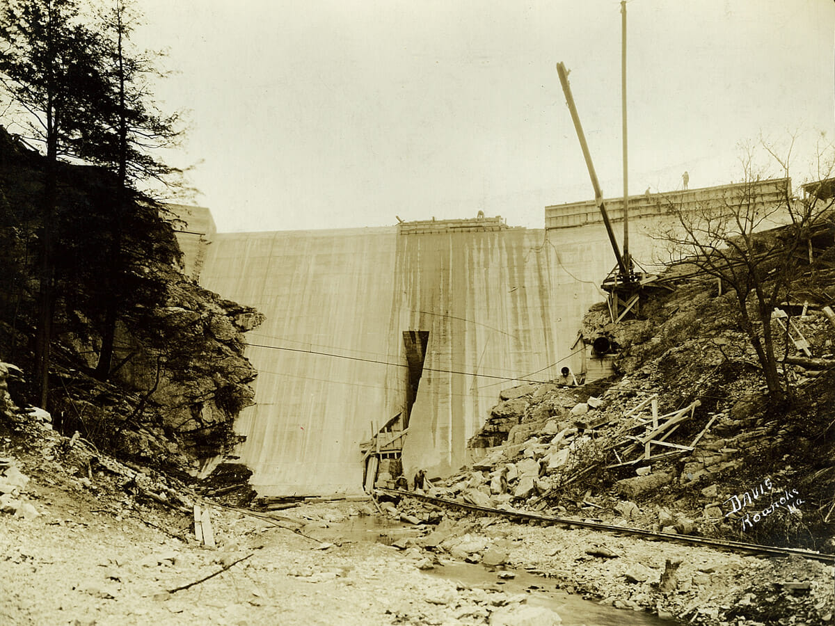
Carvins Cove History

Carvins Cove Dam downstream side, 1927

In 1746, a Welsh man named William Carvin received a land grant of 150 acres just outside of Roanoke. His homestead would later become the City of Roanoke’s primary water source and the nation’s second largest municipal park, offering a wide range of recreational activities. After Carvin passed, the region later became known as the Happy Valley community.

In 1926, Roanoke Water Works started plans to construct a $700,000 dam at Carvins Creek’s water falls. The dam would impound six billion gallons of water and become a source of fresh water for the growing urban population in Roanoke. Twelve years later, the City of Roanoke paid $4.5 million for all of the lands held by Roanoke Water Works, which included Carvins Cove. By 1944, the City voted to approve a $2.4 million bond issued to finish the Carvins Cove project. By 1947, the reservoir was completed and the filtration plant was put into operation, treating up to six million gallons of water daily. That treatment facility has since been updated and expanded, increasing the capacity to 28 million gallons per day. 

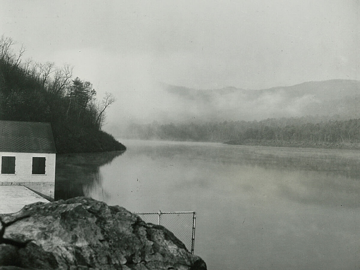
Carvins Cove History

Carvins Cove Dam looking over reservoir, 1945

In 2004, the Western Virginia Water Authority was formed and designated as the region’s water and wastewater service provider. As a result, the Water Authority gained ownership over the Carvins Cove Reservoir and land up to its 1,200-foot contour. The City of Roanoke retained ownership of the land, making Carvins Cove the second largest municipally-owned park in the United States. The remaining multi-use trails and land is managed by the City of Roanoke’s Department of Parks and Recreation. 

In 2009, the City of Roanoke donated a two-part conservation easement in Roanoke County and Botetourt County. This easement permanently protects 11,363 acres of open space in Carvins Cove Natural Reserve.

Photo source: Western Virginia Water Authority

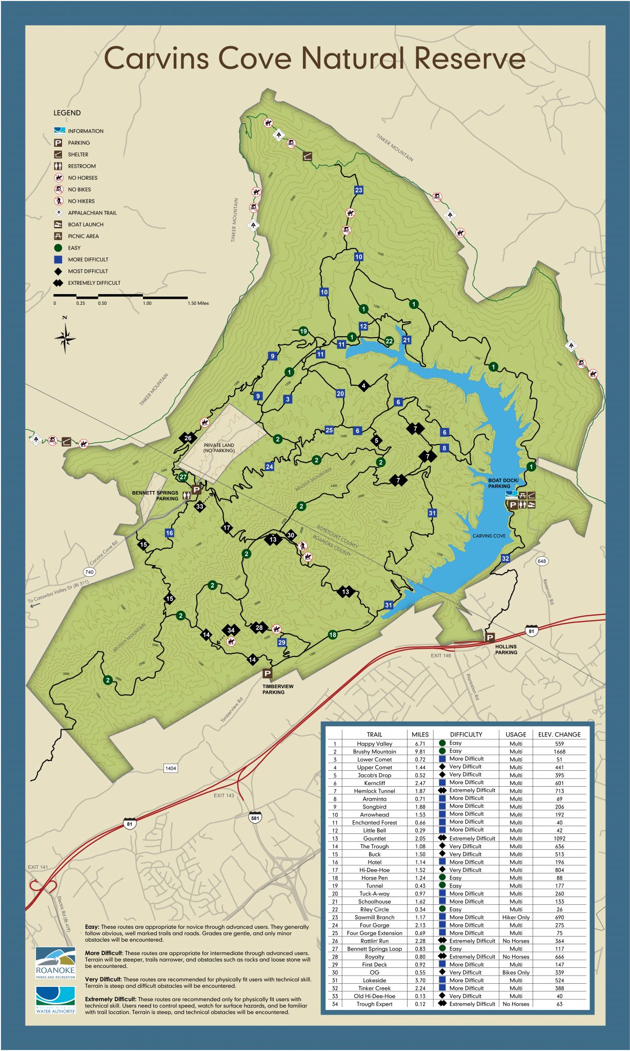
New Carvins Cove Trail Map

Download PDF

Trails at Carvins Cove

Carvins Cove Natural Reserve is one of the main reasons why Roanoke, Virginia, has been deemed the Mountain Bike Capital of the East. There are roughly 60 miles of mountain biking, hiking and equestrian trails, including cross country single track, free-ride downhill trails, and extensive gravel fire roads.

Easy: Green Circle Trails

Easy Trails: Green circle

These trails are appropriate for novice through advanced users. The trails generally follow obvious, well-marked trails and roads. Grades are gentle and only minor obstacles will be encountered. 

  • Happy Valley Trail: 6.71 Miles, Multi-Use, 559 ft of Elevation Change
  • Brushy Mountain Trail: 9.81 Miles, Multi-Use, 1668 ft of Elevation Change
  • Horse Pen Trail: 1.24 Miles, Multi-Use, 88 ft of Elevation Change
  • Tunnel Trail: 0.43 Miles, Multi-Use, 177 ft of Elevation Change
  • Riley Circle: 0.34 miles, Multi-Use, 26 ft of Elevation Change
  • Bennett Springs Loop: 0.83 Miles, Multi-Use, 117 ft of Elevation Change
More Difficult: Blue Square Trails

More Difficult Trails: Blue Square

These routes are appropriate for intermediate through advanced users. Terrain will be steeper and narrower. Obstacles such as rocks and loose stone will be encountered. 

  • Lower Comet: 0.72 Miles, Multi-Use, 51 ft of Elevation Change
  • Kerncliff: 2.47 Miles, Multi-Use, 601 ft of Elevation Change
  • Araminta: 0.71 Miles, Multi-Use, 69 ft of Elevation Change
  • Songbird: 1.88 Miles, Multi-Use, 206 ft of Elevation Change
  • Arrowhead: 1.53 Miles, Multi-Use, 192 ft of Elevation Change
  • Enchanted Forest: 0.66 Miles, Multi-Use, 40 ft of Elevation Change
  • Little Bell: 0.29 Miles, Multi-Use, 42 ft of Elevation Change
  • Hotel: 1.14 Miles, Multi-Use, 196 ft of Elevation Change
  • Tuck-A-Way: 0.97 Miles, Multi-Use, 260 ft of Elevation Change
  • Schoolhouse: 1.62 Miles, Multi-Use, 133 ft of Elevation Change
  • Sawmill Branch: 1.17 Miles, Hiker Only, 690 ft of Elevation Change
  • Four Gorge: 2.13 Miles, Multi-Use, 275 ft of Elevation Change
  • Four Gorge Extension: 0.69 Miles, Multi-Use, 75 ft of Elevation Change
  • First Deck: 0.92 Miles, Multi-Use, 147 ft of Elevation Change
  • Lakeside: 3.7 Miles, Multi-Use, 524 ft of Elevation Change
  • Tinker Creek: 2.24 Miles, Multi-Use, 524 ft of Elevation Change
Very Difficult: Black Diamond Trails

Very Difficult Trails: Black Diamond

These routes are recommended for physically fit users with technical skill. The terrain is steep and difficult obstacles will be encountered. 

  • Upper Comet: 1.44 Miles, Multi-Use, 441 ft of Elevation Change
  • Jacob’s Drop: 0.52 Miles, Multi-Use, 395 ft of Elevation Change
  • The Trough: 1.08 Miles, Multi-Use, 636 ft of Elevation Change
  • Buck: 1.5 Miles, Multi-Use, 513 ft of Elevation Change
  • Hi-Dee-Hoe: 1.52 Miles, Multi-Use, 804 ft of Elevation Change
  • OG: 0.55 Miles, Bikes Only, 339 ft of Elevation Change
  • Old Hi-Dee-Hoe: 0.13 Miles, Multi-Use, 40 ft of Elevation Change
Extremely Difficult: Double Black Diamond Trails

EXTREMELY Difficult Trails: DOUBLE Black Diamond

These routes are recommended only for physically fit users with technical skill. Users need to control speed, watch for surface hazards, and be familiar with trail locations. The terrain is steep and technical obstacles will be encountered. 

  • Hemlock Tunnel: 1.87 Miles, Multi-Use, 713 ft of Elevation Change
  • Gauntlet: 2.05 Miles, Multi-Use, 1,092 ft of Elevation Change
  • Rattlin’ Run: 2.28 Miles, No Horses, 364 ft of Elevation Change
  • Royalty: 0.8 Miles, No Horses, 666 ft of Elevation Change
  • Trough Expert: 0.12 Miles, No Horses, 63 ft of Elevation Change
Trail Maps

PDF Map: 

Carvins Cove Trail Map

Digital Map:

Trail Alerts

Know Before You Go with Statusfy trail and greenway alerts! Statusfy is an informational alert system meant to keep users informed. Statusfy allows trail and greenway users to view active and ongoing alerts (including short-term maintenance closures, long-term construction closures, flooding, detours, or event alerts). Note: Statusfy is not designed to inform users of current trail conditions or emergency situations. If you encounter an emergency in our parks, trails, or greenways – call 911. More Info Here

VIEW ALL STATUSFY ALERTS


GIVE BACK TO YOUR TRAILS.

Owned by the City of Roanoke, all of Carvins Cove’s trails are planned and managed by Roanoke Parks and Recreation, but predominantly built and maintained by volunteers. Local non-profit volunteer groups that offer continuous help and support on Roanoke’s trails include Pathfinders for Greenways, BROC, and Blue Ridge Gravity. Want to help out? Learn more about upcoming Trail Maintenance Work Days.

HOPING TO GET ON THE WATER?

Although Carvins Cove Natural Reserve is a public recreational resource, it is also home to the region’s primary water source. To help maintain clean drinking water, please abide by the rules enforced by the Western Virginia Water Authority when enjoying the Cove’s reservoir and trails. 
More Information

Other Parks

Thrasher Park
Location: 930 Old Vinton Mill Rd NE, Roanoke, VA 24012, USA
Phone: 540-853-2236
More Details
Grandin Court Park and Recreation Center
Location: 2621 Barham Rd SW, Roanoke, VA 24015, United States
Phone: 540-853-2446
More Details
Harkrader Park
Location: 2002 Colonial Ave SW, Roanoke, VA 24015, United States
Phone: 540-853-2236
More Details
Highland Park
Location: 502 Washington Avenue Southwest, Old Southwest, Roanoke, VA 24016, United States
Phone: 540-853-2236
More Details
Horton Park
Location: 2500 Salem Turnpike NW, Roanoke, VA 24017, United States
Phone: 540-853-2236
More Details
Huff Lane Park
Location: 4412 Huff Ln NW, Roanoke, VA 24012, USA
Phone: 540-853-2236
More Details
Washington Park
Location: 1610 Burrell St NW, Roanoke, VA 24012, USA
Phone: 540-853-2236
More Details
West End Park
Location: 916 Campbell Avenue Southwest, Roanoke, VA 24016, United States
Phone: 540-853-2236
More Details
Wasena Park
Location: 1001 Winchester Ave SW, Roanoke, VA 24015, United States
Phone: 540-853-2236
More Details
Belmont Park
Location: 923 Montrose Ave SE, Roanoke, VA 24013, United States
Phone: 540-853-2236
More Details
McCadden Park
Location: 1616 19th St NW, Roanoke, VA 24017, United States
Phone: 540-853-2236
More Details
Lakewood Park
Location: Brandon Ave SW, Roanoke, VA 24015, USA
Phone: 540-853-2236
More Details
Vic Thomas Park
Location: 1234 Midvale Ave SW, Roanoke, VA 24016, United States
Phone: 540-853-2236
More Details
Golden Park
Location: 1566 Carlisle Ave SE, Roanoke, VA 24014, USA
Phone: 540-853-2236
More Details
Villa Heights Park
Location: 1201 Prillaman Avenue Northwest, Roanoke, VA, USA
Phone: 540-853-2236
More Details
Smith Park
Location: 1611 Wiley Dr SW, Roanoke, VA 24015, USA
Phone: 540-853-2236
More Details
Mill Mountain Park
Location: 2000 J B Fishburn Pkwy, Roanoke, VA 24013
Phone: 540-853-2236
More Details
Sunrise Park
Location: 4225 Southern Hills Dr SW, Roanoke, VA 24014, USA
Phone: 540-853-2236
More Details
Strauss Park
Location: 644 Westside Blvd NW, Roanoke, VA 24017, USA
Phone: 540-853-2236
More Details
Staunton Park
Location: 2225 Staunton Ave NW, Roanoke, VA 24017, USA
Phone: 540-853-2236
More Details
River's Edge Park
Location: 302 Wiley Dr SW, Roanoke, VA 24014, USA
Phone: 540-853-2236
More Details
Shrine Hill Park
Location: 2102 Grandin Rd SW, Roanoke, VA 24015, USA
Phone: 540-853-2236
More Details
Loudon Park
Location: 827 Loudon Ave NW, Roanoke, VA 24016, USA
Phone: 540-853-2236
More Details
Mason Mill Park
Location: 1900 Mason Mill Rd NE, Roanoke, VA, United States
Phone: 540-853-2236
More Details
Raleigh Court Park
Location: 2330 Windsor Avenue Southwest, Roanoke, VA 24015, United States
Phone: 540-853-2236
More Details
Melrose Park
Location: 1412 MELROSE AVE NW ROANOKE, VA 24017
Phone: 540-853-2236
More Details
Valley Avenue Park
Location: Hamilton Avenue Southwest, Roanoke, VA, USA
Phone: 540-853-2236
More Details
Norwich Park and Recreation Center
Location: 2120 Roanoke Avenue Southwest, Roanoke, VA 24015, United States
Phone: 540-853-1276
More Details
Piedmont Park
Location: 102 Riverview Blvd Southeast, Roanoke, VA, United States
Phone: 540-853-2236
More Details
Perry Park
Location: 1101 Norfolk Ave SW, Roanoke, VA 24016, USA
Phone: 540-853-2236
More Details
Morningside Park
Location: 917 Morgan Avenue Southeast, Roanoke, VA 24013, United States
Phone: 540-853-2236
More Details
Ridgewood Park
Location: 720 Hemlock Rd NW, Roanoke, VA 24017, United States
Phone: 540-853-2236
More Details
Entranceway Park
Location: 114 Wells Ave NE, Roanoke, VA 24016, USA
Phone: 540-853-2236
More Details
Gateway Park
Location: 518 Orange Ave NE, Roanoke, VA, USA
Phone: 540-853-2236
More Details
Woodlawn Natural Reserve
Location: 2451 Montgomery Ave SW, Roanoke, VA 24015, USA
Phone: 540-853-2236
More Details
Andrews Park
Location: 4902 Williamson Rd, Roanoke, VA, United States
Phone: 540-853-2236
More Details
Argonne Circle
Location: King George Avenue Southwest, Roanoke, VA, USA
Phone: 540-853-2236
More Details
Yellow Mountain Natural Reserve
Location: Yellow Mountain Road Southeast, Roanoke, VA, USA
Phone: 540-853-2236
More Details
Triangle Park
Location: Kerns Avenue Southwest, Roanoke, VA, USA
Phone: 540-853-2236
More Details
Preston Park
Location: 3142 Preston Ave NW, Roanoke, VA 24012, USA
Phone: 540-853-2236
More Details
Bowman Park
Location: 2802 Meadows St NW, Roanoke, VA 24012, United States
Phone: 540-853-2236
More Details
Breckinridge Park
Location: 3901 Williamson Road Northeast, Roanoke, VA 24012, United States
Phone: 540-853-2236
More Details
Brown-Robertson Park
Location: 913 Shadeland Ave NW, Roanoke, VA 24012
Phone: 540-853-2236
More Details
Countryside Park
Location: 2365 Ranch Rd NW, Roanoke, VA 24017, United States
Phone: 540-853-2236
More Details
Eastgate Park
Location: North Avenue Northeast, Roanoke, VA, USA
Phone: 540-853-2236
More Details
Eureka Park
Location: 1529 Carroll Ave NW, Roanoke, VA 24017
Phone: 540-853-2236
More Details
Fallon Park
Location: 2116 Dale Ave SE, Roanoke, VA 24013, USA
Phone: 540-853-2236
More Details
Fern Park
Location: 2875 S Jefferson St, Roanoke, VA 24014, USA
Phone: 540-853-2236
More Details
Fishburn Park
Location: 2304 Brambleton Ave SW, Roanoke, VA 24015, United States
Phone: 540-853-2236
More Details
Garden City Park
Location: 1315 Hillview Ave SE, Roanoke, VA 24014, United States
Phone: 540-853-2236
More Details
Garden City Recreation Center and Park
Location: 3741 Yellow Mountain Road, Roanoke, VA 24014, United States
Phone: 540-853-2237
More Details
Elmwood Park
Location: 505 Williamson Road Southeast, Roanoke, VA 24011, United States
Phone: 540-853-2236
More Details